


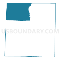
Voting District CUCL, Person County, North Carolina
About
Outline

Summary
| Unique Area Identifier | 641140 |
| Name | Voting District CUCL |
| County | Person County |
| State | North Carolina |
| Area (square miles) | 60.10 |
| Land Area (square miles) | 54.00 |
| Water Area (square miles) | 6.11 |
| % of Land Area | 89.84 |
| % of Water Area | 10.16 |
| Latitude of the Internal Point | 36.49471720 |
| Longtitude of the Internal Point | -79.06072200 |
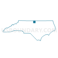
Maps

Graphs
Select a template below for downloading or customizing gragh for Voting District CUCL, Person County, North Carolina


Neighbors
Neighoring Voting District (by Name) Neighboring Voting District on the Map
- Black Walnut Voting District, Halifax County, VA
- Voting District LEAS, Caswell County, NC
- Voting District MILT, Caswell County, NC
- Mt. Carmel Voting District, Halifax County, VA
- Voting District OLHI, Person County, NC
- Voting District ROX2, Person County, NC
- Voting District RX1A, Person County, NC
- Voting District WDSD, Person County, NC
Top 10 Neighboring County Subdivision (by Population) Neighboring County Subdivision on the Map
- Roxboro township, Person County, NC (15,284)
- District 6, Halifax County, VA (4,530)
- Olive Hill township, Person County, NC (2,417)
- Milton township, Caswell County, NC (2,217)
- Cunningham township, Person County, NC (1,770)
- Woodsdale township, Person County, NC (1,502)
- Leasburg township, Caswell County, NC (1,210)
Top 10 Neighboring Unified School District (by Population) Neighboring Unified School District on the Map
- Person County Schools, NC (39,464)
- Halifax County Public Schools, VA (36,241)
- Caswell County Schools, NC (23,719)
Top 10 Neighboring State Legislative District Lower Chamber (by Population) Neighboring State Legislative District Lower Chamber on the Map
- State House District 55, NC (73,704)
- State House District 50, NC (73,491)
- State House District 60, VA (72,146)
Top 10 Neighboring State Legislative District Upper Chamber (by Population) Neighboring State Legislative District Upper Chamber on the Map
- State Senate District 15, VA (191,067)
- State Senate District 24, NC (174,850)
- State Senate District 23, NC (173,265)
Top 10 Neighboring 111th Congressional District (by Population) Neighboring 111th Congressional District on the Map
Top 10 Neighboring Census Tract (by Population) Neighboring Census Tract on the Map
- Census Tract 9202, Person County, NC (6,749)
- Census Tract 9306, Caswell County, NC (4,790)
- Census Tract 9303.02, Halifax County, VA (4,637)
- Census Tract 9301, Caswell County, NC (2,436)